Science
Hurricane Erin Surges to Category 5, Sets New Records

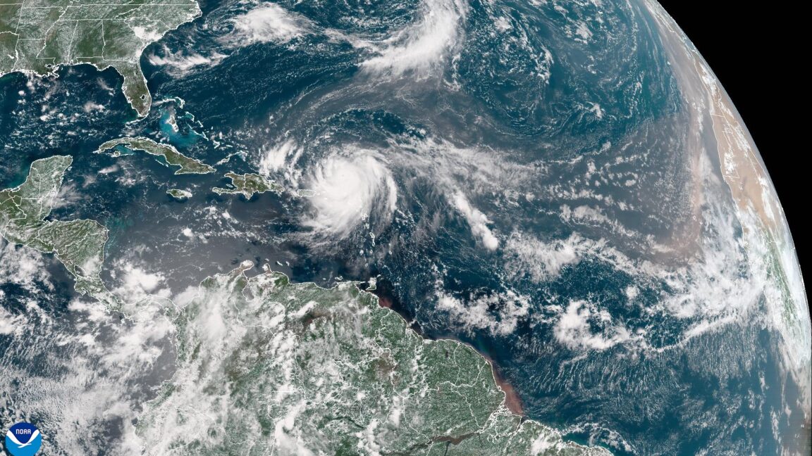
Hurricane Erin rapidly intensified into a Category 5 storm on August 30, 2023, marking a significant milestone in the Atlantic hurricane season. The storm’s sustained winds reached an impressive 160 mph, as measured by a US Air Force Hurricane Hunter aircraft. This classification reflects Erin’s explosive growth after forming just a day earlier, highlighting both its power and the changing dynamics of hurricane activity in the region.
Forecasters have reported that Erin is currently navigating north of the Caribbean islands. Projections indicate that the storm will take a path that keeps it away from major landmasses, allowing it to avoid catastrophic damage. Erin is expected to turn northward before approaching the Bahamas and the Eastern United States, ultimately charting a course between Atlantic Canada and Bermuda by the end of next week.
Historic Growth in Storm Intensity
Erin’s rapid transformation from a tropical storm to a Category 5 hurricane is unprecedented for this time of year. Meteorologist Sam Lillo noted that the storm deepened by 70 millibars within a 24-hour period, making it the most rapidly intensifying hurricane measured in the Atlantic prior to September 1. As of Saturday, Erin’s central pressure was recorded at 917 mb, ranking it as the second-most intense Atlantic hurricane in the last 50 years, surpassed only by Hurricane Allen in 1980.
While the immediate threat to land appears minimal, the storm’s historical intensity raises alarms about the increasing frequency of such events. Studies indicate that hurricanes like Erin may become more common due to climate change. A 2019 study published in Nature Communications found that the intensification rates of the strongest 5 percent of Atlantic hurricanes have increased by approximately 3–4 mph per decade from 1982 to 2009.
Climate Change and Future Storm Patterns
The consensus among experts is that although the total number of tropical storms and hurricanes may not rise significantly, the intensity of these storms is likely to increase. According to the US government’s Climate.gov website, the proportion of severe tropical cyclones—those classified as Category 4 and 5—has been rising, likely due to human-induced climate change.
The study highlighted that the number of intense storms is projected to rise further, leading to stronger winds, higher storm surges, and increased rainfall rates. As a result, while the overall number of tropical cyclones each year may stabilize or decrease, the impact of those that do form could be more devastating.
As of now, the Atlantic hurricane season has seen lower-than-average activity, but Erin’s emergence suggests that this could soon change. With the season typically peaking in early September, forecasters anticipate a surge in storms in the coming weeks, although it remains uncertain whether any will make landfall.
In summary, Hurricane Erin’s unprecedented intensification and potential future storms underscore the urgent need for ongoing monitoring and preparedness as climate conditions evolve.
-

 Science2 months ago
Nostradamus’ 2026 Predictions: Star Death and Dark Events Loom
-

 Science2 months ago
Breakthroughs and Challenges Await Science in 2026
-

 Technology3 months ago
OpenAI to Implement Age Verification for ChatGPT by December 2025
-

 Technology8 months ago
Discover the Top 10 Calorie Counting Apps of 2025
-

 Technology6 months ago
Electric Moto Influencer Surronster Arrested in Tijuana
-

 Health6 months ago
Bella Hadid Shares Health Update After Treatment for Lyme Disease
-

 Health6 months ago
Analysts Project Stronger Growth for Apple’s iPhone 17 Lineup
-

 Technology3 months ago
Top 10 Penny Stocks to Watch in 2026 for Strong Returns
-

 Health6 months ago
Japanese Study Finds Rose Oil Can Increase Brain Gray Matter
-

 Science5 months ago
Starship V3 Set for 2026 Launch After Successful Final Test of Version 2
-

 Education6 months ago
Harvard Secures Court Victory Over Federal Funding Cuts
-

 Health6 months ago
Erin Bates Shares Recovery Update Following Sepsis Complications


