Science
Archaeologists Map Expanded Roman Road Network Over 300,000 km
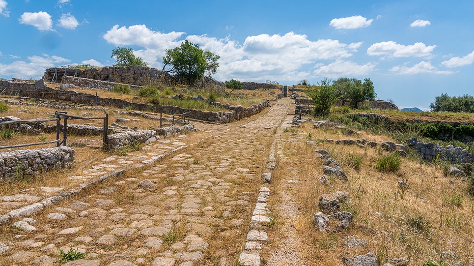
Archaeologists have made a significant discovery that expands the understanding of Roman infrastructure. A new digital atlas, named Itiner-e, reveals a Roman road network that measures nearly 300,000 kilometers (approximately 186,000 miles) across Europe, North Africa, and the Middle East—an increase of over 100,000 kilometers from previous estimates. This comprehensive mapping effort follows an amateur metal detectorist’s finding of Roman cavalry swords, which led to the unearthing of a 2,000-year-old settlement in Gloucestershire.
The newly published atlas marks the first comprehensive update in 25 years, a significant time gap during which previous maps relied on incomplete records and analog methods. Researchers utilized advanced digital techniques and satellite imaging to revolutionize the study of ancient roadways. They meticulously analyzed historical documents, ancient journals, and the locations of Roman milestones, leading to a clearer understanding of the extensive road network that supported the Roman Empire.
Innovative Research Methods Illuminate Ancient Routes
The research team spent five years combing through various archival materials while also harnessing modern technology. They utilized satellite imagery and aerial photography, including recently digitized records from World War II, to search for subtle hints of ancient pathways. When historical texts suggested the existence of lost roads, researchers examined the terrain for visual indicators, such as variations in vegetation or soil, which pointed to the presence of old Roman routes.
“It becomes a massive game of connecting the dots on a continental scale,” said Tom Brughmans, an archaeologist and co-author of the study published in Scientific Data. The findings reveal routes extending from Spain to Syria, connecting over 5,000 ancient settlements. Prior to this work, the estimated extent of Roman roads was approximately 188,000 kilometers (about 117,000 miles), primarily focusing on main highways.
The atlas sheds light on previously under-documented regions, including parts of North Africa, the interior plains of France, and the Peloponnese peninsula in Greece. “This will be a very foundational work for a lot of other research,” noted Benjamin Ducke from the German Archaeological Institute in Berlin, emphasizing the importance of this enhanced understanding of ancient road systems.
Implications for Historical Understanding
The name Itiner-e pays homage to the Ancient Roman itineraria, or travel registers, that cataloged official road stations and distances between towns. While previous compilations attempted to visualize the ancient road systems, this new atlas integrates historical documents with modern Geographic Information System (GIS) analysis, Light Detection and Ranging (LiDAR), and crowdsourced archaeological data.
According to the findings released by Scientific Data, only 2% to 3% of the mapped routes have “high certainty,” indicating that clear physical traces still exist. The remainder are classified as probable or inferred, based on multiple historical or environmental indicators. The ability to visualize the ancient routes taken by Roman farmers, soldiers, and diplomats can enhance the understanding of vital historical trends, including the rise of Christianity and the spread of ancient pandemics.
“The Romans left a huge impact with this road network,” said Adam Pažout of the Autonomous University of Barcelona. This extensive network not only influenced ancient logistics and trade but also laid the foundation for many roads still in use today. The atlas is expected to reshape scholarship surrounding imperial logistics, trade networks, and cultural diffusion.
The data and an interactive map are freely available for scholars, educators, and the public at itiner-e.org, where users can explore routes, milestones, and ancient settlements in detail. The ongoing discoveries related to Ancient Rome continue to offer valuable insights for both academic research and public interest, as recent archaeological efforts have uncovered significant relics, such as a vast stone basin in Gabii, Italy, dating back more than 2,000 years.
This new understanding of the Roman road network not only enriches historical knowledge but also invites future exploration of the ancient world, providing a deeper connection to the infrastructure that shaped civilizations.


Master Your Workouts: Prevent Overtraining for Better Results

Astronomers Capture Nearby Galaxy Cluster Merging Event

Salmonella Outbreak Linked to Raw Oysters Hospitalizes 20 Across 22 States

U.S. Chip Restrictions Propel China’s Tech Surge Amid Investor Shift

Tips to Prevent Overtraining and Enhance Your Workout Results

Drones Innovate Wildfire Detection and Suppression Techniques

Measles and Flu Cases Surge in the Carolinas: Urgent Health Alert

Internet Users Bypass Redactions in Epstein Files Release

Community Invited to Join Native Planting Day at Humboldt Coastal Nature Center

Discover the Top 10 Calorie Counting Apps of 2025

OpenAI to Implement Age Verification for ChatGPT by December 2025

Bella Hadid Shares Health Update After Treatment for Lyme Disease

Analysts Project Stronger Growth for Apple’s iPhone 17 Lineup

Erin Bates Shares Recovery Update Following Sepsis Complications

Discover How to Reverse Image Search Using ChatGPT Effortlessly

Electric Moto Influencer Surronster Arrested in Tijuana

Meta Initiates $60B AI Data Center Expansion, Starting in Ohio

Discover 2025’s Top GPUs for Exceptional 4K Gaming Performance
-
 Technology5 months ago
Discover the Top 10 Calorie Counting Apps of 2025
-
 Technology3 weeks ago
OpenAI to Implement Age Verification for ChatGPT by December 2025
-
 Health3 months ago
Bella Hadid Shares Health Update After Treatment for Lyme Disease
-
 Health4 months ago
Analysts Project Stronger Growth for Apple’s iPhone 17 Lineup
-
 Health4 months ago
Erin Bates Shares Recovery Update Following Sepsis Complications
-
 Technology5 months ago
Discover How to Reverse Image Search Using ChatGPT Effortlessly
-
 Technology3 months ago
Electric Moto Influencer Surronster Arrested in Tijuana
-
 Technology5 months ago
Meta Initiates $60B AI Data Center Expansion, Starting in Ohio
-
 Technology2 months ago
Discover 2025’s Top GPUs for Exceptional 4K Gaming Performance
-

 Technology5 months ago
Recovering a Suspended TikTok Account: A Step-by-Step Guide
-

 Health5 months ago
Tested: Rab Firewall Mountain Jacket Survives Harsh Conditions
-

 Lifestyle5 months ago
Belton Family Reunites After Daughter Survives Hill Country Floods