Education
Hurricane Erin Intensifies, Threatens Life with Dangerous Surf

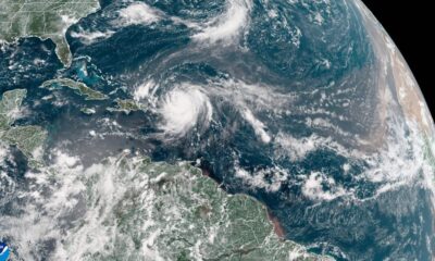
Hurricane Erin has rapidly intensified into a powerful Category 4 storm, posing significant risks of life-threatening surf and rip currents along the US East Coast and Bermuda. This expansive storm has already begun to impact areas such as Puerto Rico, leading to flash flooding and widespread power outages.
Erin’s outer rain bands have affected Puerto Rico, where approximately 100,000 residents lost power. According to the National Hurricane Center, additional rainfall of up to 2 inches is expected through Monday night, with a flood watch still in effect. The storm’s influence is also spreading to the southeast Bahamas and the Turks and Caicos Islands, bringing heavy rainfall and warnings of potential flooding.
Life-Threatening Conditions Expected
While Erin is expected to remain offshore, its massive wind field is already generating large swells and dangerous rip currents along the East Coast. From South Carolina to the New Jersey shore, authorities warn of increased rip current risks from Tuesday through Thursday. The National Weather Service in Morehead City, North Carolina, emphasized that even without direct landfall, the danger from high surf is substantial. “This is not the week to swim in the ocean,” cautioned Dare County Emergency Management in a recent evacuation order.
As a precaution, Dare County has declared a local state of emergency, mandating evacuations for Hatteras Island. Officials expect coastal flooding to begin as early as August 19, 2025, persisting through August 21, 2025. Portions of North Carolina Highway 12 may become impassable due to ocean overwash.
In Bermuda, forecasters anticipate rough seas and possibly tropical storm-force winds in the coming days. The storm’s vast reach means that even areas far from its center will experience its effects, leading to dangerous beach conditions.
Rapid Intensification and Future Risks
Hurricane Erin has been noted for its extreme rapid intensification, moving from tropical storm strength to Category 5 within a day, peaking at winds of 165 mph. This rapid change underscores how quickly hurricanes can strengthen in a warming climate. Although Erin has since weakened slightly while undergoing an eyewall replacement cycle, it has re-intensified to Category 4 as of Monday.
This hurricane marks the first of the Atlantic’s 2025 season. While other systems, such as Andrea, Barry, Chantal, and Dexter, have emerged this year, none have reached hurricane status until Erin. Meteorologists are also monitoring a tropical wave behind Erin that may develop into another storm in the coming days.
As the Atlantic hurricane season progresses, forecasters predict heightened activity, especially as typical peak conditions from mid-August to mid-October approach. Although Erin has churned up cooler waters beneath its surface, there remains an abundance of warm waters that can fuel further storm development.
As officials continue to monitor Hurricane Erin, the focus remains on public safety, particularly for those in coastal areas. The risks associated with rip currents and flooding are stark reminders of the potential dangers posed by such powerful storms.
-

 Technology4 weeks ago
Discover the Top 10 Calorie Counting Apps of 2025
-

 Lifestyle1 month ago
Belton Family Reunites After Daughter Survives Hill Country Floods
-

 Education1 month ago
Winter Park School’s Grade Drops to C, Parents Express Concerns
-

 Technology2 weeks ago
Discover How to Reverse Image Search Using ChatGPT Effortlessly
-

 Technology3 weeks ago
Harmonic Launches AI Chatbot App to Transform Mathematical Reasoning
-

 Technology1 month ago
Meta Initiates $60B AI Data Center Expansion, Starting in Ohio
-

 Lifestyle1 month ago
New Restaurants Transform Minneapolis Dining Scene with Music and Flavor
-

 Technology1 month ago
ByteDance Ventures into Mixed Reality with New Headset Development
-

 Technology1 month ago
Recovering a Suspended TikTok Account: A Step-by-Step Guide
-

 Technology4 weeks ago
Mathieu van der Poel Withdraws from Tour de France Due to Pneumonia
-

 Technology1 month ago
Global Market for Air Quality Technologies to Hit $419 Billion by 2033
-

 Health1 month ago
Sudden Vision Loss: Warning Signs of Stroke and Dietary Solutions


